Exhaustive, illustrated trail-guides, with detailed trekking maps, on the most popular treks in the Himalayas

Home
Guidebooks
Trekking Maps
Buy Online
Contact Us
Annapurna: Trekking Map  Buy Now

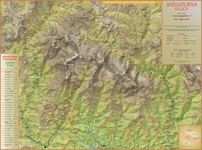
Detailed, easy-to-read fold-out trekking map showing
all major trails and roads. Contour-coloured so that users can
visualise the lay of the land, picturing mountain ranges
and other relief features with ease.

The map covers the entire Annapurna region, from
Pokhara to Kagbeni in the north, showing not only the
the Annapurna Circuit and Sanctuary trails, but also
routes to Naar-Phu and Tilicho Lake and other less
frequented tracks. The Manaslu and Dhaulagiri ranges, visible
from several locations on the Circuit trek, are also shown.

Most major settlements and campsites shown on the trails,
as also peaks, are marked along with their altitudes,
in both metres and feet.

 
Annapurna
Trekking Map
Fold-out map enclosed in folder
Folder size: 4.5x10.25in./ 11.4x26 cm
Scale 1:125,000
Map size 29.5 x 22 in./ 75 x 56 cm
Published in 2009
by Milestone Books, India
Price US$ 5.00
(plus shipping and handling)
Price in India Rs 225
(plus Rs 50 for shipping and handling)
Click to view a section of the map in true scale
 

Home  |  Browse Books  |  Buy Online  |  Contact UsLinksSite Map

[© 2006-2021 Milestone Books, Calcutta, India.] [Best viewed IE 6.0 and above at 800x600 pixel display]